By Cam Campbell and Grant Statham
This article was originally published in The Avalanche Journal, Vol. 138, Summer 2025
The Avalanche Terrain Exposure Scale (ATES) is a system used to assess and communicate the severity of avalanche terrain and potential hazard exposure. Ratings are determined using both subjective and objective criteria that result in a measure of avalanche terrain exposure on an ordinal scale. It was introduced in 2004 in Canada as a guidebook-style terrain rating system for recreational backcountry trips and later expanded into a zoning model to accommodate spatial applications.
Since its introduction, ATES has been applied in many different jurisdictions and countries, has become a widely used risk management and avalanche education tool, and has been used by researchers to measure terrain use preferences. In Canada, use of ATES has grown beyond recreational applications into policy and regulatory frameworks. It is now widely used in workplace avalanche safety plans and Parks Canada uses it for custodial group management.
Over the past two decades, advances in technology and geospatial tools have facilitated a broader application of the ATES concept, including automated ATES ratings (Larsen et al., 2020), which greatly expand the potential scope of terrain classification. Simultaneously, the growth of backcountry recreation has furthered the need for improved avalanche terrain tools (Klassen, 2012) to meet the needs of both skilled backcountry users and those with no appetite for avalanche risk. Backcountry terrain-use patterns have changed, and ATES needed to change with them.
This article introduces ATES v.2 and contains excerpts from our recent peer-reviewed paper in Natural Hazards and Earth System Sciences (NHESS) (Statham & Campbell, 2025), which is freely available online (URL provided in the references). This version merges the two previous ATES models into a single method that:
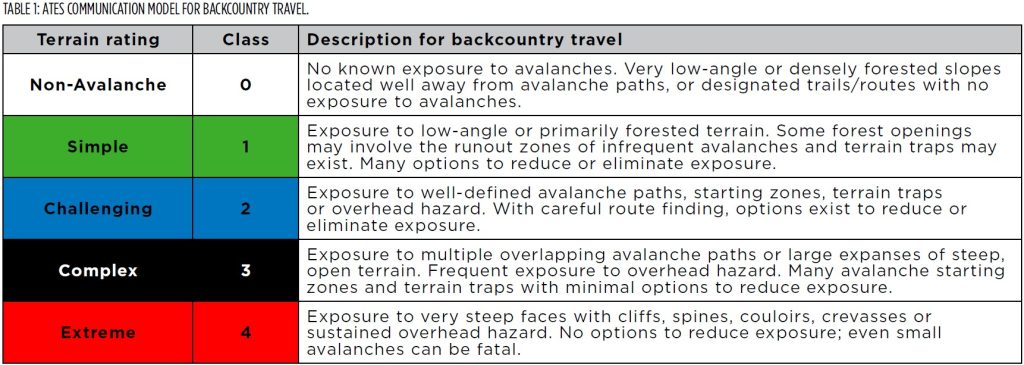
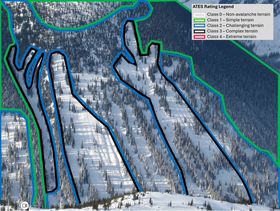
- expands the original version to five levels from three by including Class 0 – Non-avalanche terrain and Class 4 – Extreme terrain;
- removes glaciation as an input parameter; and
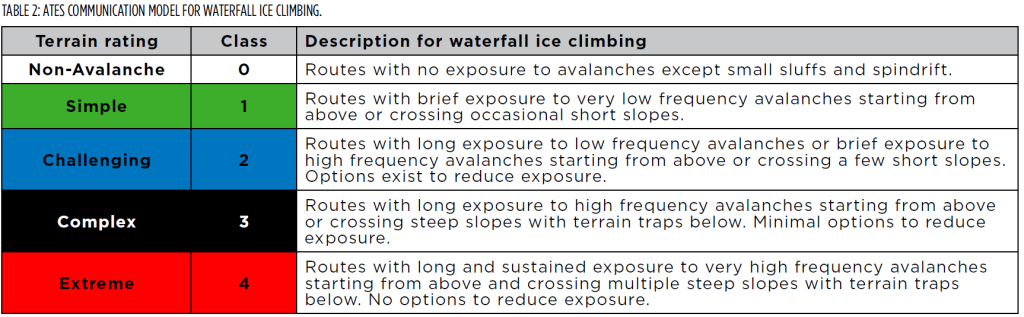
- introduces a communication model for waterfall ice climbing.
This update also addresses shortcomings identified over the past 20 years of extensive ATES use. Note that ATES v.2 was originally presented at the 2023 International Snow Science Workshop in Bend, Oregon; however, it has seen a few revisions since then.
ATES V.2
ATES v.2 is a five-level terrain rating system that helps people gauge their exposure to avalanche-prone terrain. It follows the communication theory of source–channel–receiver (Wogalter et al., 1999), with dual objectives of assessment and communication, each with respective models. The communication models are simple by design to achieve ATES’ primary objective of conveying terrain ratings to different receiver groups. The technical model is designed for the source (i.e., the terrain assessor) as a specialized reference for identifying, analysing, and classifying avalanche terrain exposure.
Communication models
The communication models describe terrain ratings in the language of the receiver. They are light on technical detail and prioritize comprehension. ATES v.2 contains two communication models, each for activities with distinct exposure characteristics: backcountry travel (Table 1) and waterfall ice climbing (Table 2). The models describe and rank avalanche terrain in a simple way, similar to how the danger scale describes and ranks avalanche danger. They represent the summary of a technical assessment intended for avalanche risk communication to less-experienced users.
ATES v.2 technical model
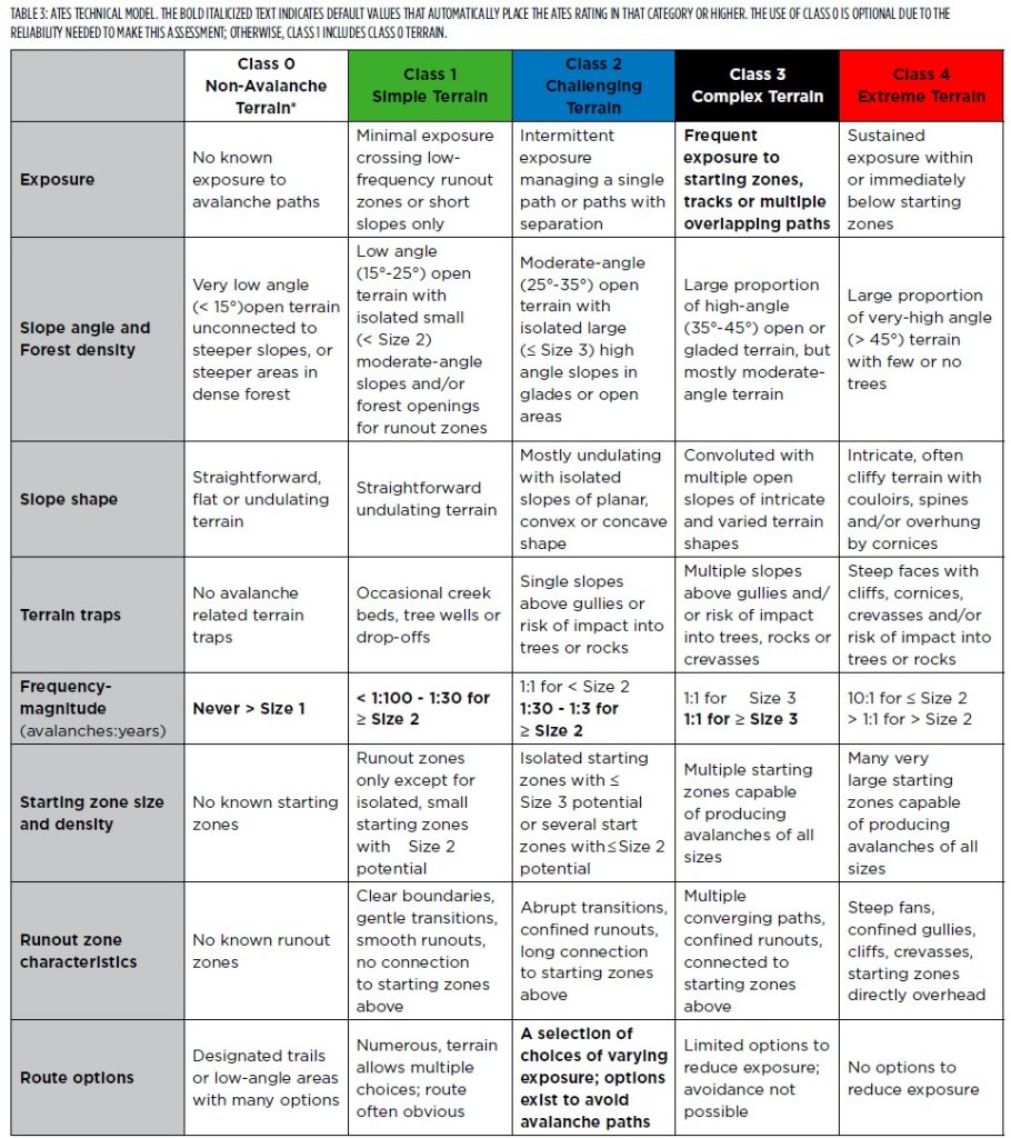
The technical model describes avalanche terrain exposure using eight parameters, each with thresholds for the five ATES classification levels. Of a total of 40 criteria, there are six bold defaults that, when met, automatically default the ATES rating into that category or higher. Otherwise, the overall rating is an evaluation based predominantly on expert judgement that involves analysing the terrain against each ATES parameter for the best fit, comparing this to levels above and below, and deciding what the best overall rating is. More guidance for evaluating each parameter to determine an overall rating can be found in our NHESS paper.
APPLICATION
Objectives and approach
Over the past two decades, ATES projects have used different approaches to meet different objectives or use emerging technology. Examples include the manual rating of backcountry touring routes, mixed GIS and manual mapping/rating of backcountry zones, and automated, algorithm-based mapping/rating.
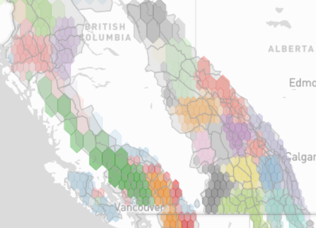
Typically, a more objective approach leads to smallerscale zoning around measurable terrain features, such as in Alberta Parks’ AutoATES maps for Kananaskis (see article on page 35). This is different than a manual approach, where terrain is often grouped into zones that are logical for a recreational application (such as Avalanche Canada’s Trip Planner), but this requires local expertise. Striking the right balance of objective measurements (e.g., slope angle), subjective estimates (e.g., frequency-magnitude), and local knowledge (e.g., route options) is a challenge for the assessment of any ATES rating. Ultimately, ATES is a communication tool and the resulting product must make sense and be easily interpreted by the receiver of the information.
The application of ATES starts by considering the objectives of the final product, which informs the approach to assessment and communication. The objective and approach depend on the target audience, their intended use of the terrain ratings, and the availability of terrain data. For example, the objective might be to facilitate recreational trip-planning, in which case a single rating for a specific area or
route might be sufficient (or multiple ratings along that route for a more precise assessment). ATES zone-mapping might be more appropriate if you’re creating an avalanche safety plan for roving field work that uses ATES ratings to dictate what kind of terrain can be accessed for a given avalanche danger.
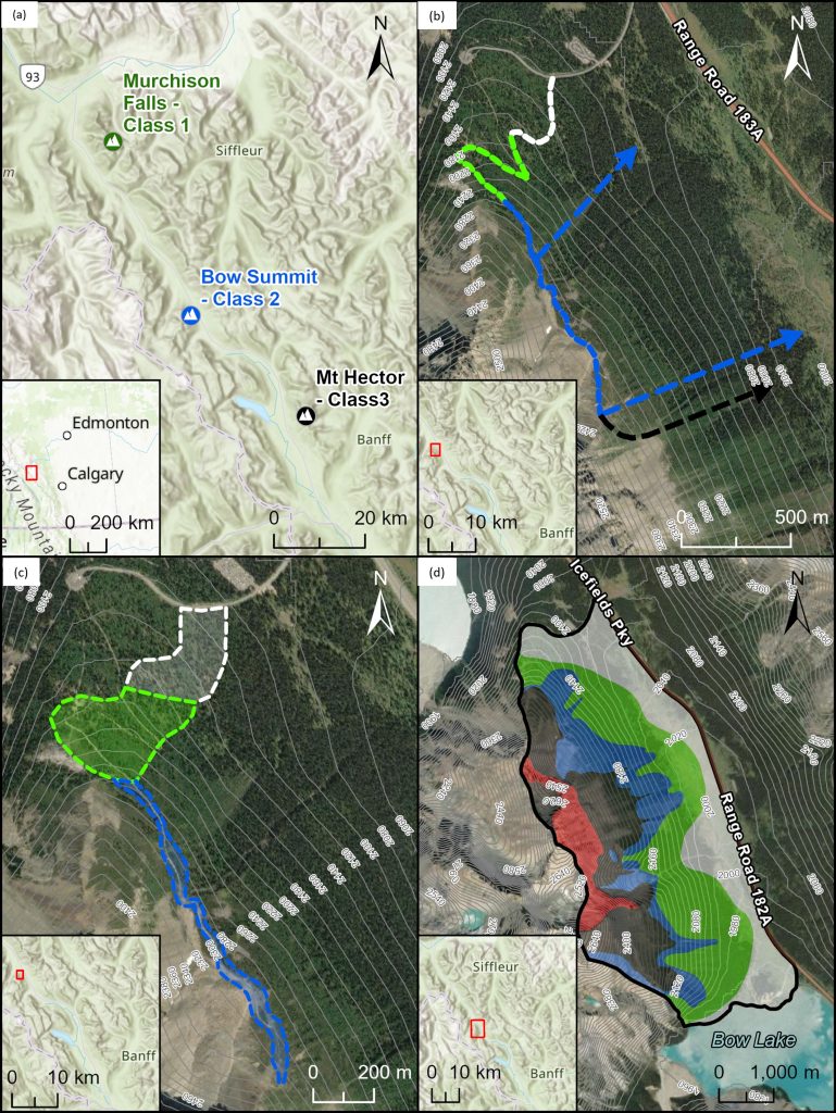
Over the past 20 years of use, four distinct approaches to ATES classification have emerged. These are listed in Table 2 and illustrated in Figures 1 and 2.
An area defines the boundaries of an overall assessment and can either be given a single rating (Figures 1a and 3) or be broken down into smaller-scale zones (Figures 1d and 3). A route defines a linear path of travel from start to finish and can be broken down into shorter segments using lines to represent precise routes (Figure 1b) and polygons to represent a corridor of travel where navigational freedom
is possible (Figure 1c). A zone is a specific slope or grouping of terrain features with common ATES characteristics that is represented by a polygon, and is typically surrounded by adjacent polygons showing ATES zone ratings (Figure 1d).
Spatial scale
Spatial scale refers to the extent of a geographic area and the resolution at which ATES is applied. For example, when classifying a predetermined route, the scale of the entire area is already defined by the route. However, along that route there will be variations in avalanche exposure.
These could be represented using smaller-scale ratings for improved accuracy, or they could be grouped together as part of the whole route and only a single rating issued. The smaller the scale, the higher the resolution and more precise the classifications will be, but this comes at the cost of greater effort and resources. It is important to determine at which scale the ratings are being applied and to recognize that not all the criteria shown in Table 1 can be applied at all scales.
Assessment methods
Evaluating avalanche terrain exposure using ATES requires qualified people skilled in avalanche terrain assessment and backcountry route-finding. ATES is intended to be used by both avalanche professionals and desktop GIS specialists, or ideally a team of both. Assessors ultimately develop their own techniques and work within the bounds of their scope of practice and organization’s capacity, but the most accurate results are achieved through collaboration. Local terrain and route familiarity are a significant asset and necessary for analysing the interaction between people and avalanche terrain.
AutoATES (Toft et al., 2024) is an emerging automated approach that enables efficient large-scale ATES mapping in a standardized manner. It uses GIS-based algorithms to identify potential avalanche release areas and calculate runout extent, then combines these results with forest cover data and slope angles derived from digital elevation data to determine ATES ratings for individual grid cells (i.e., pixels) in a raster surface. See John Sykes’ article on page 31 for more on AutoATES.
Rating avalanche terrain using ATES can be straightforward for single routes with single ratings. For uncomplicated terrain with good data, such as a well-travelled trail with only a few avalanche paths or an alpine bowl with high-quality mapping and imagery, sufficient accuracy can often be achieved without field surveys or complex analyses. For more complicated projects such as large areas with extensive avalanche terrain, unfamiliar travel routes, significant overhead hazard, or a need for small-scale ATES zones, a more rigorous approach and level of effort are necessary. Typically, this uses some combination of GIS analysis, field investigations, aerial photographs, satellite image interpretation, climate analysis, and runout estimation.
The level of effort put into ratings and review also depends on the objectives. For example, if the objective is a high-level trip-planning decision tool, then a desktop review for inconsistencies may be all that is necessary; however, if it will be used as a navigational aid, then thorough peer review and field-checking is probably warranted.
PARTING WORDS
Terrain rating systems play an essential risk management role in recreational outdoor activities such as climbing, hiking, kayaking, skiing, and biking. Industries where workers are exposed to avalanche risk also rely on terrain rating systems to enable occupational health and safety policies. Combined, these systems have helped millions of users plan and execute their activities by simplifying complex terrain attributes into easily understood categories that can be used to manage risk and improve their experience.
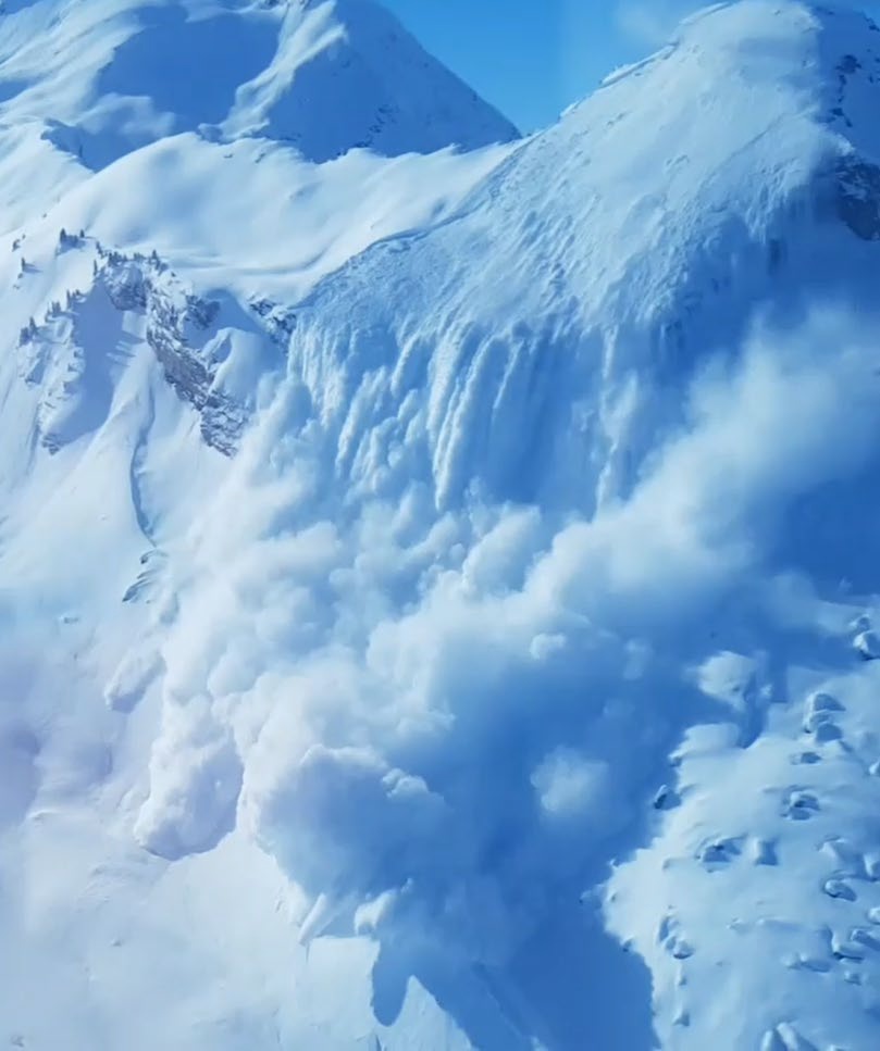
Backcountry avalanche risk is a complex interaction between snowpack, terrain, and people, where terrain is the only constant factor. It is often said: “When snow is the problem, terrain is the solution.” For decades, professional guides have considered terrain assessment and route selection to be the principal mitigating factors in backcountry avalanche risk management—when nothing is exposed, nothing is at risk.
However, communicating to a lay person how to evaluate avalanche terrain and manage risk in the backcountry is challenging, as the subject is complex with many technical variables that are easily lost upon the target audience. The classic slope-angle-based terrain choice method (Landrø et al., 2020), which has dominated avalanche decision-making strategies for decades, is limited in its scope. Its attraction is it is easy to understand, measurable, and accurate for human triggering inside avalanche starting zones. However, slope angle alone does not account for important factors such as propagation, overhead hazard, terrain traps, avalanche frequency, and the concept of exposure in general, which are the fundamentals of backcountry avalanche risk management. Including them in a simple, five-level terrain classification system that can be understood easily by the receiver is important in the same way that the danger scale helps people to categorize and understand the level of avalanche danger in a simple way.
Public avalanche bulletins warn about the current backcountry avalanche danger, but this is only part of the avalanche risk equation. Ultimately, people choose their own risk by making decisions about where, when, and how they travel. Even during periods of high danger, reducing exposure can lower or eliminate the risk. In small-scale terrain features, a few metres in either direction can be the difference between low- and high-risk situations. Thus, controlling terrain exposure is the most important avalanche risk management skill necessary for winter backcountry travel. The objective of ATES is to make that more explicit and easier to understand for backcountry users.
REFERENCES
Avalanche Canada, Trip Planner: https://avalanche.ca/planning/trip-planner, last access: 05 November 2024.
Delparte, D.: Avalanche Terrain Modeling in Glacier National Park, Canada. Ph. D. Thesis, University of Calgary, Calgary, AB, Canada. 195 pp, 2008.
Gavaldà, J., Moner, I., Bacardit, M.: Integrating the ATES into the avalanche information in Aran Valley (Central Pyrenees), in: Proceedings International Snow Science Workshop, Chamonix, France, 7-11 October 2013, 381-384, https://arc.lib.montana.edu/snow-science/item.
php?id=1984 (last access: 21 April 2024), 2013.
Klassen, K.: Incorporating Terrain into Public Avalanche Information Products, in: Proceedings International Snow Science Workshop, Anchorage, AK, USA, September 16-21, 209-2013, https://arc.lib.montana.edu/snow-science/item.php?id=1582 (last access: 12 May 2024), 2012.
Landrø, M., Pfuhl, G., Engeset, R., Jackson, M., and Hetland, A.: Avalanche decision-making frameworks: Classification and description of underlying factors, Cold Reg. Sci. Technol., 169, 102903, https://doi.org/10.1016/j.coldregions.2019.102903, 2020.
Larsen, H. T., Hendrikx, J., Slåtten, M. S., Engeset, R. V.: Developing nationwide avalanche terrain maps for Norway. Natural Hazards (Dordrecht), 103(3), 2829–2847. https://doi.org/10.1007/s11069-020-04104-7, 2020.
Parks Canada: Avalanche Terrain Ratings for the Mountain National Parks. First edition. Parks Canada, Banff, Canada, ISBN 0-662-38737-6, 2004.
Parks Canada: Public information package for custodial groups planning winter backcountry travel, https://parks.canada.ca/pn-np/mtn/securiteenmontagnemountainsafety/gardiens-custodial, last accessed 21 April 2024, 2005.
Scott, C and Klassen, M.: Alpine Ski Tours in the Canadian Rockies, 3rd ed. Rocky Mountain Books, Calgary, A.B., Canada, 344 pp, ISBN 978-1-926855-78-3, 2011.
Sharp, E., Campbell, C., Statham, G., Schroers, B.: A standardized multiscale, fuzzy GIS data model for ATES mapping. International Snow Science Workshop, Bend, USA, 2023.
Statham, G., and Campbell, C.: The Avalanche Terrain Exposure Scale (ATES) v.2, Nat. Hazards Earth Syst. Sci., 25, 1113–1137, https://doi.org/10.5194/nhess-25-1113-2025, 2025.
Toft, H. B., Sykes, J., Schauer, A., Hendrikx, J., and Hetland, A.: AutoATES v2.0: Automated Avalanche Terrain Exposure Scale mapping, Nat. Hazards Earth Syst. Sci., 24, 1779–1793, https://doi.org/10.5194/nhess-24-1779-2024, 2024.
Wogalter, M. S., DeJoy, D., and Laughery, K. R.: Organizing theoretical framework: a consolidated communication human information processing (C-HIP) model, in: Warnings and risk communication, CRC Press, 29–37, https://doi.org/10.1201/9780203983836, 1999.