
A New Way to Estimate Snowpacks in the Canadian Rockies
By Christopher B. Marsh1, Vincent Vionnet2,1, and John W. Pomeroy1
1 Centre for Hydrology, University of Saskatchewan, Canmore and Saskatoon, Canada
2 Meteorological Research Division, Environment and Climate Change Canada
This article originally appeared in The Avalanche Journal, Vol. 131, Winter 2022-23.
INTRODUCTION
In the Canadian Western Cordillera, spring snow melt supplies the majority of water that generates streamflow, recharges lakes, wetlands, and groundwater, and results in the largest river discharge events of the year. Globally, billions of people depend on mountain headwaters for fresh water (Viviroli et al., 2007). In Canada, over 60% of the flow of the Saskatchewan River is provided by melting snow and almost all of this comes from the Canadian Rockies headwaters (Pomeroy et al., 2005). There is significant motivation to improve predictions of this critical water storage to aid in water supply forecasts for downstream floods, hydroelectricity generation, irrigated agriculture withdrawals, ecosystem management, reservoir management, ecotourism, and drinking water withdrawals. These snow covers are also a critical component of ski and snowboard tourism, safe backcountry travel, and infrastructure protection. The alpinist, avalanche professional, and snow hydrology research communities share a common interest in quantifying the variability of these snow covers, and how they are changing due to climate and land-use change.
Mountain snow covers are highly variable in space and time due to many interacting factors. Snow cover heterogeneity is principally influenced by the transport of blowing snow (Pomeroy et al., 1993; MacDonald et al., 2019; Mott et al., 2010; Marsh, et al., 2020; Vionnet, et al., 2021) leading to the loss of up to 30-40% of total winter precipitation in alpine regions (MacDonald et al., 2010; Mott et al., 2018). Wind scours snow from ridgetops, forms deep snow drifts in the lee of ridges and at treeline, and forms avalanches (Bernhardt and Schulz, 2010) that often start in deep snow drifts formed on the leeward side of ridges.
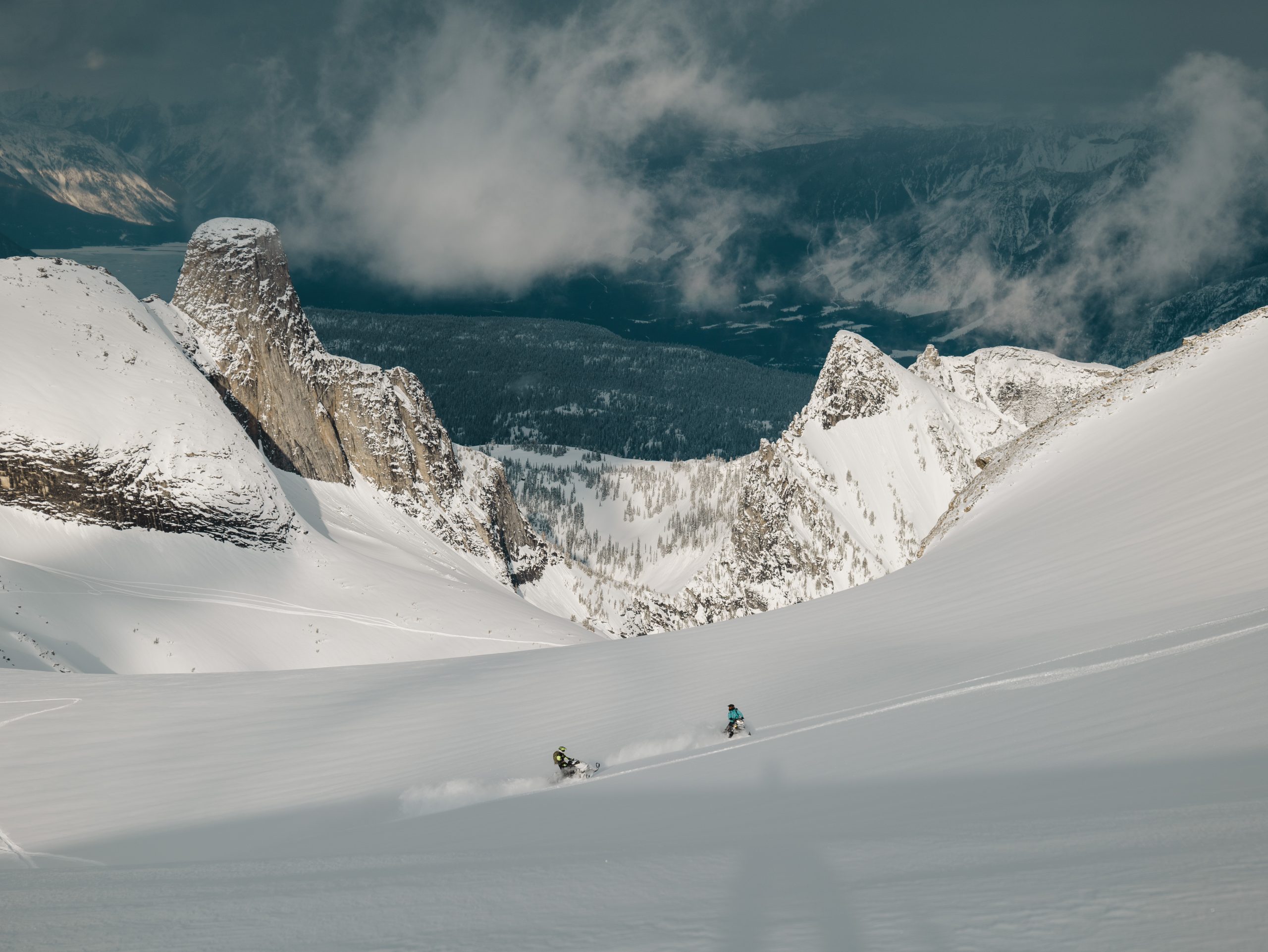
Avalanches transport snow from high-elevation, lower-meltrate locations to higher-melt-rate, lower elevations located down slope and in valley bottoms (Bernhardt and Schulz, 2010). They create areas of significant snow depth at the base of steep slopes (Bernhardt and Schulz, 2010), which may be shaded locations that allow the deposit to persist late into the summer. These can also supply extra snow to glaciers. These deep and cold snow accumulation locations can be found at lower elevations, which impacts the rate and timing of snow cover ablation (DeBeer and Pomeroy, 2017). Figure 1 shows an example of the spatial variability of snow cover resulting from blowing snow and avalanches.
The forest canopy is also very important to the development of mountain snow covers (Pomeroy and Gray, 1995). Snow is intercepted in canopies for periods from hours to weeks in winter. It is subject to sublimation to water vapour, unloading from the canopy, or melt in situ on the canopy, from where it drips to the ground (Pomeroy et al., 1998; Ellis et al., 2010). This results in “tree wells” of shallow snow under isolated evergreens and much lower snow accumulation under dense forests than in nearby clearings.
It is exceptionally difficult to observe snow depth and snow water equivalent (SWE) over large areas. Direct observation via snow courses and automatic stations are spatially sparse (DeBeer et al., 2021) and tend to be confined to low-to-mid elevations, sheltered sites, and forest clearings. Snow pit observations can provide detailed information of the snowpack, but only at one site, and so do not represent the heterogeneity of mountain snowpacks. This results in biased sampling and under-measurement of high-elevation mountain snow covers.
Remote-sensed observations of snow cover from aircrafts, Unmanned Aerial Vehicles (UAV), and satellites have increased in availability and fidelity over the past 20 years (Hopkinson et al., 2012; Deems et al., 2013; Tedesco et al., 2014; Painter et al, 2016); however, none are by themselves a complete solution. Airborne laser altimetry (lidar) and structure-from-motion photogrammetry provide high-resolution observations of the elevation of the snow surface in open areas, but it is unable to reliably sample snow depth under dense forest canopies (Hopkinson et al., 2012; Schirmer and Pomeroy, 2019; Harder et al., 2016, 2020). Satellite lidar and microwave are at a coarse spatial resolution, have limited repeats, and are highly uncertain in forested and steep terrain (Treichler and Kaab, 2017). Thus, the accurate prediction of snow cover via numerical models is therefore an avenue of interest for estimating SWE. This is only possible when incorporating the full set of snow processes such as blowing snow and avalanching.
THE CANADIAN HYDROLOGICAL MODEL
The Canadian Hydrological Model (CHM) (Marsh et al., 2020b) is a numerical modelling framework that enables the accurate and timely estimates of snowpacks by including key mountain snow processes that have so far been ignored in water supply models. This includes blowing snow, avalanching, snow interception and sublimation, and the impact of terrain shading, slope and aspect on snow melt rates.
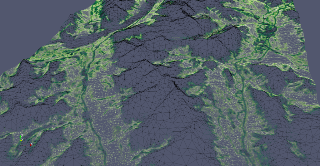
A key innovation of the CHM is how topography is represented. Most hydrological and atmospheric models consider the ground to be flat and either ignore or lump landscapes together using a fixed grid. The CHM uses variably sized triangles to represent the topography. Each triangle is a computational element with a unique and individually simulated SWE and blowing snow transport flux. In areas with complex and varying topography, where increased fidelity is required, smaller triangles are used to better represent the landscape. For example, they may be used to capture the details of an alpine ridge or the transition from forest to alpine. Where the topography and land cover are more homogenous, such as open prairies, larger triangles can be used. By using larger triangles, fewer total triangles are required, reducing the
computational requirements.
Judicious use of variably sized triangles allows the landscape to be represented with often only 1% of the total number of computational units that was previously needed to be used in fixed-resolution models. This reduces the computational burden and allows for simulating larger regions and incorporating snow redistribution and melt processes that are critical for snow cover heterogeneity. These triangles are shown in Figure 2 where, from left, the triangles are made increasingly coarser and thus represent the landscape less and less well. Figure 3 shows a set of variably sized triangles that were generated to capture the transition from treeline to alpine. The triangles are shaded green corresponding to vegetation density (unitless), with the darker green denoting higher density. Smaller triangles are found along river valleys and at treeline in order to capture these important areas.

In the CHM, snow accumulation and ablation are simulated by solving the energy balance equation to determine the energy from solar and thermal radiation, turbulent transfer from the atmosphere, condensation of water vapour, energy advected from rainfall, and energy conducted from soil or rocks available to sublimate and melt the mountain snowpack. This approach, versus simpler approximations that are based only on air temperature, ensures much higher fidelity in calculating melt rates in complex mountain terrain, forested and open environments; and for both current and future climates, as it is not calibrated to sparse historical observations. Energy balance snow models are the only type that can accurately predict snow melt due to mid-winter melts and rain-on-snow events; and to snowpacks on shaded or very sunlit slopes.
The redistribution of alpine snow by wind, its in-transit sublimation, and the associated loading of snow drifts on leeward slopes are explicitly simulated in the CHM. This simulation is the result of almost 40 years of blowing snow studies in various environments, including Scotland, Canada, and the U.S. (Pomeroy, 1989). Wind speed and turbulence estimates are necessary to calculate blowing snow fluxes. In the CHM, they are provided by using an approximation to a numerical wind flow model that ensures fast run times (Wagenbrenner et al., 2016).
The avalanching scheme used in the CHM is a method to redistribute snow to lower slopes by gravity (Bernhardt and Schulz, 2010). It is not a 3D avalanche model that simulates the timing of avalanche release and subsequent flow dynamics. In its current configuration, it cannot be
used to assess avalanche hazards, paths, extents, or provide hazard forecasting.
Accounting for this type of snow redistribution for hydrological purposes is different from classical avalanche hazard forecasting, although both require understanding of high alpine snow covers. Rather, the snow gravity redistribution calculation in the CHM is just an information tool to permit more accurate mapping of SWE by moving high-elevation snow to lower elevations based on observed relationships between slope steepness and snow depths after avalanching.
The model also deals with the effects of treeline and sub-alpine forests on snow accumulation, interception, sublimation, and sub-canopy snow melt. In summary, the CHM provides unique information for the distribution of snow over large mountain areas because it is capable of fine scale calculations (e.g., 50 m length scale on ridges) and scalable to continental areas.
SIMULATION OF MOUNTAIN SNOW COVERS
In Vionnet, et al (2021), the CHM was used to simulate the mountain snow covers around the Kananaskis valley on the eastern slopes of the Canadian Rockies. This study combined:
- the atmospheric forcing from the Environment and Climate Change Canada numerical weather prediction system at a 2.5-km grid spacing (Milbrandt et al, 2016); and
- a wind-downscaling strategy relying on a diagnostic wind model capable of generating realistic estimates of wind speed and direction at 50-m resolution in alpine terrain.
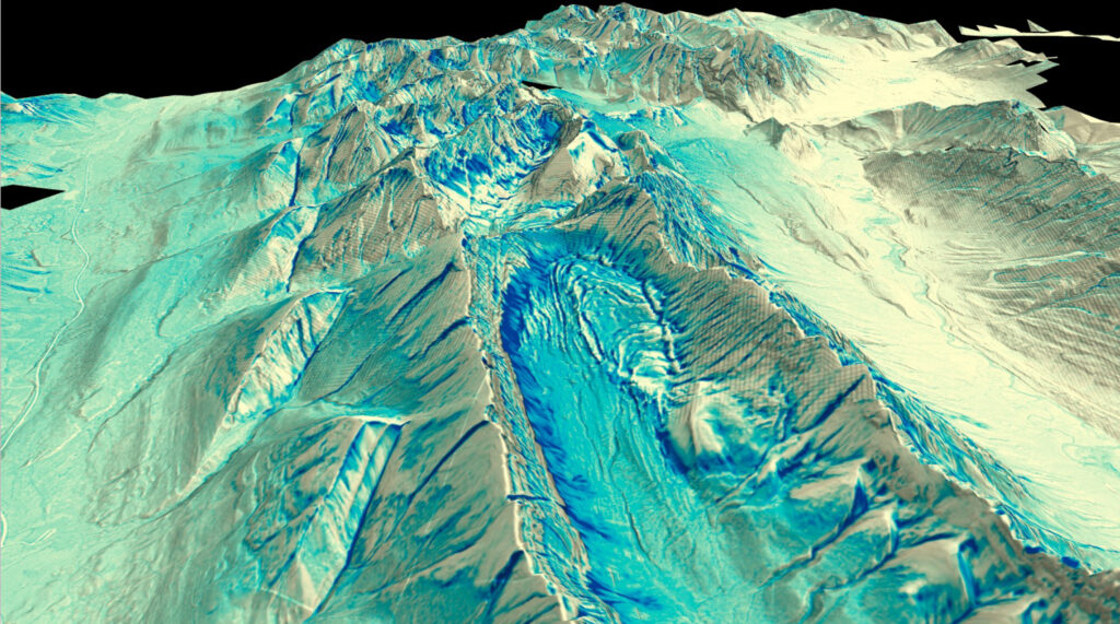
Covering an area of 958 km2, the study area is characterized by a complex and rugged topography with elevations ranging from 1,400 m at valley bottom up to 3,406 m at the summit of Mount Sir Douglas (Fig. 4). The region is an active snow hydrology research area and includes several research basins, snow surveys, and high-elevation weather stations that are part of the University of Saskatchewan’s Canadian Rockies Hydrological Observatory.

Vegetation cover (Fig. 3) follows elevational gradients, with variation due to surficial geology, slope, and aspect. Evergreen forests predominantly cover the lower slopes and valley bottoms; short shrubs and low vegetation are present just above treeline; and exposed rocks, glaciers, talus, and grasses are found in the highest alpine elevations and on steep slopes at lower elevations.
Model evaluation was done against airborne lidar surveys. The measurements were taken from two flights: one on Oct. 5, 2017, (late-summer) and a second on Apr. 27, 2018, (winter scan) by Professor Brian Menounos and his team at the University of Northern British Columbia. These observations had a horizontal and vertical positional uncertainty of ±15 cm (one standard deviation).
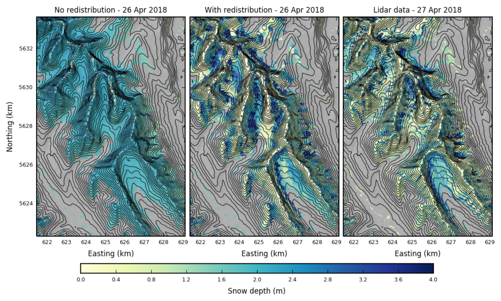
The configuration of the CHM used in Vionnet, et al (2021) included the critical winter processes identified as important in this region: energy balance calculations for snowpack melt and sublimation; terrain shadowing, slope, and aspect for incoming solar radiation; precipitation type (rainfall vs. snowfall) estimation; forest canopy snow interception, melt, and sublimation; blowing snow redistribution; and avalanching. To quantify the impact of not including key processes, a falsified simulation was performed where avalanching and blowing snow were not enabled. These results are shown in Figure 5.
Snowpack simulations without blowing snow and gravitational snow redistribution were not able to simulate the spatial variability of snow cover in alpine terrain. Without these processes, there was a significant overestimation of snow depth and snow cover duration at high elevations. Including these processes improved the model results dramatically and reduced the snow depth over-estimation at high elevations. Including these processes provided the best estimates of the shape of the elevation-snow depth relation across the region and reproduced the decrease in mean snow depth found at high elevation, something intrinsic to mountain snowpacks around the world (Pomeroy and Gray, 1995).
DISCUSSION
High mountain headwaters are a critical supply of freshwater for downstream ecosystems and communities. Blowing snow and avalanche redistribution are key processes that move snow from high to low elevations, or to shaded, north aspects, where snow melts more slowly. The deep snow drifts and avalanche deposits have an inordinately important role in summer streamflow; sustaining glaciers and perennial snowfields; and supplying water for treeline forests and valley bottom wetlands (DeBeer and Pomeroy, 2010; Pradhananga and Pomeroy, 2022; Pomeroy et al., 2012).
Observed changes in air temperature and precipitation due to climate variability and climate change will continue to have profound global impacts on high-mountain snow. DeBeer et al., (2021) summarized the majority of observed snowpack changes in western Canada where warmer air temperatures are a dominant cause of change (Brown et al., 2011). These changes led to reduced snow cover extent, snow depth, and snow-covered periods due to an earlier spring and more frequent mid-winter melts (Brown et al., 2020; Musselman et al., 2021; DeBeer et al., 2021; Mudryk et al., 2018). The increased occurrence of mid-winter melts at mid and high elevations that are snow covered late in the season (McCabe et al., 2007; Corripio et al., 2017); and rain-on-snow events have profound implications for the structure of the snowpack, such as the creation of ice lenses.
The exact impact of warming snow covers on avalanche formation remains unknown (Strapazzon et al., 2021), however, there is evidence there may be a decrease in midwinter low-elevation avalanches and an increase in the occurrence of wet-snow avalanches (Strapazzon et al., 2021). Pomeroy et al., (2015) predicted a 50% reduction in blowing snow transport and decrease in sublimation of 30% with climate warming of 5 C in the front ranges of the Canadian Rockies. There are therefore reasons to expect a substantial reduction in the ability of blowing snow to supply snow to cornices that supply avalanches in the future, and profound implications for the distribution of snow cover and the existence of melting snow patches and glaciers in the summer.
There is a timely need to forecast potential changes to mountain snow covers due to climate and landscape change, and increased water supply prediction needs downstream. To do so requires advanced next-generation numerical models like the CHM that are coupled with expert in situ knowledge and observations. A strength of the CHM is its ability to calculate wind loading on slopes in complex terrain, which is critical for mountain blowing snow and avalanche calculations. It is anticipated model improvements will lead to a new form of fine-scale snow prediction that can be made available over large areas and coupled with Environment and Climate Change Canada’s weather forecast system, but available at resolutions down to tens of metres. The quasi-operational tool SnowCast (www.snowcast.ca), where the CHM is run in a forecast mode, is an example of such a tool that could potentially pair well with citizen science snow observations and help alleviate the gaps in point observations of snow covers. Although it cannot be used to inform about avalanche hazard risks, it shows the spatial development of the mountain snow cover. It is hoped that tools such as Snowcast can support broader conversations in the mountain community about snow in the mountains.
The alpinist, snow avalanche professional, and snow hydrology research communities are all facing the impacts of rapidly changing mountain climates and snow regimes. This has led to the inability to predict future snow based on the past. These communities need to continue to strive to better understand this changing environment, its changing snow and the repercussions for all those who depend on these areas for recreation, livelihoods, homes, water supply, climate regulation and the appreciation of natural environments.
REFERENCES
Bernhardt, M., & Schulz, K. (2010). SnowSlide: A simple routine for calculating gravitational snow transport. Geophysical Research Letters, 37(11).
Brown, R. D. & Robinson, D. A. (2011). Northern Hemisphere spring snow cover variability and change over 1922–2010 including an assessment of uncertainty. Cryosphere 5, 219–229.
Brown, R., Marsh, P., Déry, S. & Yang, D. (2020) .Arctic Hydrology, Permafrost and Ecosystems. 61–99 . doi:10.1007/978-3-030-50930-9_3
Corripio, J. & López-Moreno, J. (2017). Analysis and Predictability of the Hydrological Response of Mountain Catchments to Heavy Rain on Snow Events: A Case Study in the Spanish Pyrenees. Hydrology 4, 20.
Deems, J. S., Painter, T. H., & Finnegan, D. C. (2013). Lidar measurement of snow depth: a review. Journal of Glaciology, 59(215), 467-479.
DeBeer, C. M. & Pomeroy, J. W. (2010). Simulation of the snowmelt runoff contributing area in a small alpine basin. Hydrology and Earth System Sciences 14, 1205 1219.
DeBeer, C. M. & Pomeroy, J. W. (2017). Influence of snowpack and melt energy heterogeneity on snow cover depletion and snowmelt runoff simulation in a cold mountain environment. J Hydrol 553, 199–213.
DeBeer, C. M., Wheater, H. S., Pomeroy, J. W., Barr, A. G., Baltzer, J. L., Johnstone, J. F., Turetsky, M. R., Stewart, R. E., Hayashi, M., Kamp, G. van der, Marshall, S., Campbell, E., Marsh, P., Carey, S. K., Quinton, W. L., Li, Y., Razavi, S., Berg, A., McDonnell, J. J., Spence, C., Helgason, W. D., Ireson, A. M., Black, T. A., Elshamy, M., Yassin, F., Davison, B., Howard, A., Thériault, J. M., Shook, K., Demuth, M. N. & Pietroniro, A. (2021).
Summary and synthesis of Changing Cold Regions Network (CCRN) research in the interior of western Canada – Part 2: Future change in cryosphere, vegetation, and hydrology. Hydrol Earth Syst Sc 25, 1849–1882.
Ellis, C., Pomeroy, J. W., Brown, T. & MacDonald, J. (2010). Simulation of snow accumulation and melt in needleleaf forest environments. Hydrology and Earth System Sciences 14, 925 940.
Harder, P., Schirmer, M., Pomeroy, J., & Helgason, W. (2016). Accuracy of snow depth estimation in mountain and prairie environments by an unmanned aerial vehicle. The Cryosphere, 10(6), 2559-2571.
Harder, P., Pomeroy, J. W. & Helgason, W. D. (2020). Improving sub-canopy snow depth mapping with unmanned aerial vehicles: lidar versus structure-from-motion techniques. Cryosphere 14, 1919–1935.
Hopkinson, C. (2007). The influence of flying altitude, beam divergence, and pulse repetition frequency on laser pulse return intensity and canopy frequency distribution. Can J Remote Sens 33, 312–324.